


mon vert florac

bruno38
User
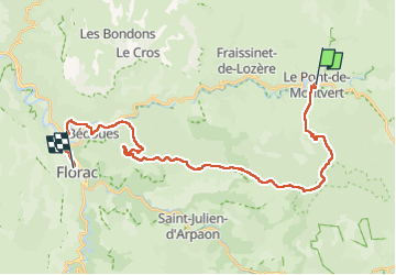

Length
30 km

Max alt
1421 m

Uphill gradient
824 m
Km-Effort
42 km

Min alt
538 m

Downhill gradient
1150 m
Boucle
No
Creation date :
2022-04-27 06:12:11.381
Updated on :
2022-04-27 13:42:16.877
7h06
Difficulty : Very difficult

FREE GPS app for hiking
 SityTrail
IGN / Geographical institutes
SityTrail Plus
The world is yours!
About
Trail Walking of 30 km to be discovered at Occitania, Lozère, Pont de Montvert - Sud Mont Lozère. This trail is proposed by bruno38.
Positioning
Country:
France
Region :
Occitania
Department/Province :
Lozère
Municipality :
Pont de Montvert - Sud Mont Lozère
Location:
Unknown
Start:(Dec)
Start:(UTM)
559300 ; 4912478 (31T) N.
Comments